The proposal team
We are seeking to bring forward the existing land in our ownership at Little Blagdon Farm for much needed housing development in the Torbay area.
We have appointed a design team comprising an Architect, Planning Consultant, Highways and Drainage Consultant, Ecologist and Landscape Architect.
KTA Architects based in Exeter have been appointed to lead the design team to develop a suitable scheme. AR Land and Planning based in Torbay will lead on planning matters and manage the planning application. GE Consulting’s Exeter office is leading on ecology , protection of species and biodiversity. Highways and Drainage design is provided by ourselves (Torbay Council). David Wilson Partnership is leading on landscape & visual sensitivity of the proposal
Proposed site layout

Background to our plans
The proposal below is the approved phased masterplan from 2016 for Collaton St Mary.
The principle of residential development around Totnes Road was established by the Torbay Local Plan 2012-2030 and forms part of a Future Growth Area under Policy SS2.
Scope for approximately 460 homes in and around Totnes Road to meet future housing need is identified in the associated Local Plan policies.
Following the Local Plan designation, the site was identified for new high quality housing within the Collaton St Mary Masterplan, being a Supplementary Planning Document (SPD) adopted February 2016.
The masterplan image below is extracted from this SPD, and is led by a landscape and ecology approach. It shows the phases in the Masterplan.
Our proposals build on this work previously undertaken in identifying and designating this site for residential development and will provide approximately 240 homes.

Image text:
- Phase 1 - 25 to 30 homes plus flats (blue outlined area)
- Phase 2 - 130 t0 135 homes (orange outlined area)
- Phase 3 - 180 to 185 homes (yellow outlined area)
- Phase 4 - 105 to 110 homes (pink outlined area)
Some homes are already being built as noted below. Some are subject to planning applications. For comparison our proposals will cover approximately 2/3rds of Phase 2 and all of Phase 3 which is approximaetly 275 homes.
What will affect the site
Constraints and Opportunities
Constraints and opportunities are factors we review that can affect the design that emerges on the site.
The site has been inspected and analysed in detail by our design team to understand the constraints and how these may shape the design of the proposed layout. The key constraints are the sites physical topography, ecology and flood matters. These and other constraints that influence development are described and illustrated below.
Ecological constraints
New homes and public open space positioned in the least sensitive areas.
The below plan highlights important ecological features including bat dark corridors and potential bat roosts, stream buffers, protected species, designated and priority habitats.

Physical constraints:
This refers to topography, visibility access, flooding, utilities, neighbours and connecting the development to its surroundings.
- Topography: Contour lines show steep slopes up to Brake Copse - A major impact on road layout and house levels.
- Visual impacts: Purple area has greater visual impact viewed from surrounding countryside if built on.
- Access: Off Totnes Rd. This has planning approval.
- Flooding: Blue zone plus 10 metre no-build buffer.
- Springs: 10m buffer. Spring can be diverted.
- Utility services: Orange are cables. Water main blue. To be re-routed.
- Neighbouring homes: Privacy buffer -overlooking
- Connections: New links for transport, pedestrian and emergency access.

Existing Masterplan Review
The existing masterplan 2016 builds upon the Local Plan allocation and provides more detailed advice and guidance. Our design team has reviewed it to inform how our new housing proposal can remain faithful to its design principles.
Principles of the existing masterplan:
- Landscape - Ecological and green infrastructure led
- People - Enhance the existing community
- Fit - Well integrated and coherent expansion of the village responding to its local characteristics
- Connectivity - Creating appropriate pedestrian and transport links
- Access - Off Totnes Rd
- Building It - A phased long term development strategy
- Flooding - ‘No-build’ zones
Our new proposal will respect these principles, but:
- Topography - Our new lay-out will work much better with existing slopes
- Connectivity - Explore cycle paths, nature trails, access for emergency vehicles
- Drainage - Establish a practical strategy
Our new housing development on the site will work with the site topography and integrate and connect into the existing context. Our new proposals will use the existing masterplan below as a design guide to achieve this. Our review of the 2016 masterplan finds a significant portion would be excessively steep to construct with practical and cost implications.

Existing 2016 masterplan above - Its proposed green corridor reinforces existing landscape features making use of the flood risk zone along the stream where homes should be avoided. Above and below- the cul-de-sac arrangements will run uphill - steep gradients would impact highway design compliance and be costly to construct roads and plots.

Our Key Design Principles
Our team explains the key design principles which influence the indicative proposal.
Overview of principles
Developable zones and limiting visual impact
The image below shows our proposal underlaid and sitting in zones F4-F7 having the least visual impact on the skyline.

Image text:
Area A - Low lying area, high levels of containment, well related to existing settlement surrounding buildings influence character. Moderate - low level sensitivity.
Area B - Sloping valley sides, high level of containment on lower slopes, influenced by surrounding settlement, existing buildings detract from landscape quality. Low level of sensitivity.
Area C - Sloping valley sides, moderate levels of containment and some longer views out. character influenced by surrounding development which detracts from landscape quality. low level of sensitivity.
Area D - Sloping valley sides. open character with views towards sea and surrounding landscape moderate levels of landscape sensitivity.
Area E - Steeply sloping upper valley sides. Prominent hillsidewith long views over surrounding landscape and to sea. Little connection to existing settlement. Woodland is prominent landscape feature and heavily influences character of the rest of Area E. High sensitivity to change.
Area F - Steeply sloping upper valley sides and hilltop. Prominent hillside with long views over surrounding landscape and to sea. Little connection with existing settlement. Part of a landscape feature visible from much of local area. High sensitivity to change.
Topography and visibility affect suitability for development. Lower areas, F5, F6, and parts of F4 and F7, are less visible and better connected to existing development and more appropriate for building with potential for effective mitigation. In contrast, mid-slope zones are more exposed and less integrated, posing greater visual impact.
The highest areas near the skyline and Brake Copse are very sensitive and inappropriate to develop. Our proposal nestles in the lower less visible areas.
Green space and public open space
The below image illustrates the principles for green infrastructure zones and open space used by the public. The principle of central green ribbon from the 2016 masterplan is retained.

Design principles concern retention and enhancement. Almost all existing vegetation is retained and where new homes and roads are proposed. These developed areas will be supplemented with generous planting. The central green infrastructure ribbon indicated in the 2016 masterplan is adhered to.
Community allotments are proposed plus opportunities for orchard zones. Hedge line removal will be minimal to limit impact on biodiversity and bat corridors.
Highways, movement and connections
The below image illustrates the highways layout. The loop shape is a direct response to the steep topography. The layout forms links to adjacent areas so that the development is properly integrated and connected with the wider area.

Our proposed highways layout differs from the existing 2016 masterplan in that we illustrate a closed loop rather than a spine road with multiple cul-de-sacs. Our scheme works with the steep topography rather than against. We run with the contours to achieve the most efficient road layout and still provide good connectivity by foot, car or cycle to the wider context. Our loop is designed to allow a light bus service adding further connectivity.
Indicative Layout Proposal
Our proposal would provide approximately 240 new homes with 30% being affordable, split between rented and shared ownership.
The proposals respond positively to the Local Plan allocation, Collaton St Mary Masterplan (SPD), Paignton Neighbourhood Plan, policies and guidance. This will provide much needed housing, whilst retaining existing vegetation, and incorporating supplementary planting, open space, play facilities and attention to landform to ensure that development is judged as an attractive, integrated logical extension to Collaton St Mary.
The form of the development responds well to the existing topography and landscape, while respecting neighbouring properties. Where possible, the proposals retain and enhance biodiversity and ecology through careful management of features important for protected species and high value habitats. The development will also deliver through the provision of onsite public open space (including equipped play) good connectivity for new and existing residents.
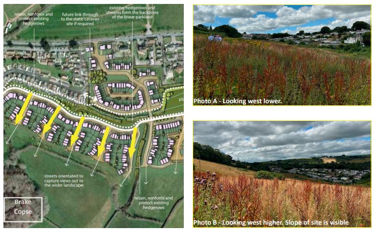
The image below shows the proposal in the wider context of Collaton St Mary.

- Access - Primary access of Totnes Road (1a).
- Future connectivity - Links (1b) to the west and east.
- Layout- The loop design (2a) enables site-wide negotiable access with pedestrian links (2b) between levels.
- Ecology and green space - Development is contained in areas (3a) with least ecological impact with retention and enhancement of green infrastructure. Proposed green landscape ribbon (3b) runs centrally.
- Scale - Generally 2 storey with split level 21/2 storey homes (4a) to some areas.
- Dwelling types - 1,2,3 and 4 bed homes are illustrated.
- Public spaces - Play areas (5a), alloments (5b),nature trails (5c), orchards (5d).
- Visual impact - Proposals are contained in the natural bowl of the site.
The image below is enlarged to show the main detail of the proposal

What happens next?
We will review all the feedback received and will use it to help inform a further update to the proposals. We will then submit an application for outline planning consent for consideration.
Once the application has been submitted, a further round of consultation will take place where there will be an opportunity for you to have your say on the final plans. In due course, councillors will discuss the proposals at a planning committee meeting before coming to a decision on the plans.